


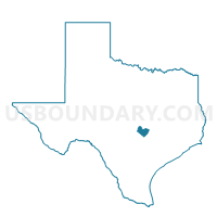
Voting District 0403, Travis County, Texas
About
Outline

Summary
| Unique Area Identifier | 677774 |
| Name | Voting District 0403 |
| County | Travis County |
| State | Texas |
| Area (square miles) | 32.09 |
| Land Area (square miles) | 32.09 |
| Water Area (square miles) | 0.00 |
| % of Land Area | 99.99 |
| % of Water Area | 0.01 |
| Latitude of the Internal Point | 30.08082290 |
| Longtitude of the Internal Point | -97.71555560 |
Maps


Graphs
Select a template below for downloading or customizing gragh for Voting District 0403, Travis County, Texas


Neighbors
Neighoring Voting District (by Name) Neighboring Voting District on the Map
- Voting District 0228, Hays County, TX
- Voting District 0234, Hays County, TX
- Voting District 0303, Caldwell County, TX
- Voting District 0304, Caldwell County, TX
- Voting District 0402, Travis County, TX
- Voting District 0404, Travis County, TX
- Voting District 0405, Travis County, TX
- Voting District 0406, Travis County, TX
- Voting District 3020, Bastrop County, TX
Top 10 Neighboring County Subdivision (by Population) Neighboring County Subdivision on the Map
- Austin CCD, Travis County, TX (774,229)
- Kyle-Buda CCD, Hays County, TX (66,181)
- Cedar Creek-Red Rock CCD, Bastrop County, TX (25,834)
- Lockhart CCD, Caldwell County, TX (22,448)
Top 10 Neighboring Place (by Population) Neighboring Place on the Map
Top 10 Neighboring Unified School District (by Population) Neighboring Unified School District on the Map
- Austin Independent School District, TX (636,113)
- Hays Consolidated Independent School District, TX (67,886)
- Del Valle Independent School District, TX (59,558)
- Bastrop Independent School District, TX (46,645)
- Lockhart Independent School District, TX (23,728)
Top 10 Neighboring State Legislative District Lower Chamber (by Population) Neighboring State Legislative District Lower Chamber on the Map
- State House District 45, TX (205,670)
- State House District 47, TX (198,311)
- State House District 17, TX (166,171)
- State House District 51, TX (158,774)
Top 10 Neighboring State Legislative District Upper Chamber (by Population) Neighboring State Legislative District Upper Chamber on the Map
- State Senate District 25, TX (984,664)
- State Senate District 14, TX (872,176)
- State Senate District 18, TX (861,831)
Top 10 Neighboring 111th Congressional District (by Population) Neighboring 111th Congressional District on the Map
Top 10 Neighboring Census Tract (by Population) Neighboring Census Tract on the Map
- Census Tract 109.07, Hays County, TX (10,854)
- Census Tract 24.26, Travis County, TX (7,490)
- Census Tract 109.08, Hays County, TX (7,256)
- Census Tract 9508.02, Bastrop County, TX (6,387)
- Census Tract 9601.01, Caldwell County, TX (5,626)
- Census Tract 24.28, Travis County, TX (5,618)
- Census Tract 24.36, Travis County, TX (2,672)
- Census Tract 24.32, Travis County, TX (2,070)
- Census Tract 24.34, Travis County, TX (1,718)
Top 10 Neighboring 5-Digit ZIP Code Tabulation Area (by Population) Neighboring 5-Digit ZIP Code Tabulation Area on the Map
- 78640, TX (42,954)
- 78610, TX (23,502)
- 78617, TX (22,210)
- 78747, TX (14,808)
- 78616, TX (7,092)
- 78719, TX (1,764)